Thursday, 6 February 2020

Batemans Bay Floods Feb 2020

 "Greater chance of flooding after devastating bush fires this summer." - Fact

Rains follow drought.  Yes, even moderate rains have the potential to cause severe flooding, landslides and devastation not only along the banks of the Clyde River but to the smaller streams and rivers.

Bushfires dramatically change the terrain.  The ground is charred, barren and unable to absorb water or even hold the water for a short period after a shower.  The rain falls and runs down the slope gather more water as it proceeds.  It causes greater erosion and moves all before it until it reaches a gully where it forms a stream which due to the compound effect becomes a flood.  Yes even in the creek behind your house.


Floods, mudflows and landslides are the next challenge we in the South Coast will have to face even during the early rebuilding phase. 

Just imagine heavy rain along the side of the Kings Highway with no vegetation to hold the soil.  The culverts full of water and the high embankments with dead and blackened trees teetering on the edge ready to topple with the next gust of wind.  A landslide or even a minor mud slide could cut the road without any warning. 

Emergency services without the fear of a fire storm could clear the highway within hours and we would not have to face another disruption but what if they closed the road “for your safety” until they can assess the potential danger.  What would that do to our already fragile mental health.

But that is not the real issue.  When the rains come they always flow into the rivers and creeks.  The Clyde and the Tomakin rivers.  With no protective vegetation it will rush towards the sea down the major arterial rivers.  Now we know or so the GHD consultants tell (Transport for NSW) that the CBD and MacKay Park will flood with a one in a hundred year flood with just normal vegetation on the banks but they did not model after these devastating fires with the blackened ground cover.

And what of the two sets of bridge piles still in the river just upstream of the town?  GHD modelling indicated a significant increase in erosion and turbulence with moderate flooding.

The Association is not being alarmist however we do know that there are inadequate water craft in the area to be tasked to assist people caught in these potential flood situations.  The question is what has Council done to prepare for this potential challenge?  It appears that they had an out of date bushfire plan and it appears they have no flood mitigation or response plan.  They do however have a Tomakin flood study indicating where the flood waters will rise to but that may well be to guide for building approvals.  BUT plans nil.

The matter of the impact of the ash on the water quality and ecology and fish will be the subject of a future post.

Thursday, 9 January 2020

When will the old BB Bridge rise again?

Construction on the new bridge has been suspended so the need to move large vessels through the bridge is not required but the bridge team has been scrambled to get the bridge operational immediately.


Not an easy task with the potential damage to the many safety systems now required to just lift the span.

Is it a legislative requirement? or is it just to get the "local" economy going again with the two lift per day.
Maybe it is a safety move to use the ferry as an evacuation platform for the people at Nelligan and those who live along the river.
It may even be the first step to construct a set of floating pontoons west of the bridge so the ferry and other expedition vessels can start and stop without the required bridge lift.
But anyway you look at it with $2 billion from the bushfire recovery fund there will be a flood of money for these types of projects. We may even get floating pontoons along the waterfront of the CBD if the Shire is not the allocator of the funds.
A community based Committee should be set up with real decision making powers as to how these funds will be distributed because if it is left to the current local government alone they will just continue with the past mistakes highlighted so evidently over the past month. A clear, independent analysis with wide contributions will have to be undertaken when the smoke clears. If not we will again see the school halls and pink batts fiasco repeated.

Saturday, 14 December 2019

Bay bar dredging delayed to after busy holiday period.


On the 29 September 2019 the Association wrote a FB post to inform local boaters and others about the dredging of the Batemans Bay Bar during the period 7 October to 20 November.  The dredging was as a result of a petition the local marina initiated to try to increase the “safety” of those crossing the bar during the summer months as vessels traverse the east coast of NSW – not to mention the increase in income as a result of this access.   The petition received 461 responses so the Local Member responded and with the usual rent a crowed announced the investment in this “important project”.

The facts around the reason and the unintended consequences of this particular operation depositing the dredging spoils in the middle of the Bay were ignored and only vested interests listened too.

On the 8 November the Association again raised the question of why dredge the bar now See https://www.facebook.com/BBBoaters/posts/838914683189664   More Dangers within the Bay.

Again the Association raised concerns but highlighted the consequences and stated: The dredging should be delayed until the GHD modelling and investigation is complete. (This consultancy is funded by Transport for NSW).  The Association has for a long time held that introducing the sand back into the bay will have dangerous unintended consequences that could cause water inundation of the locals properties and even the CBD.

We appealed to the local Minister to stop the dredging during this busy holiday period.

So what went wrong?  The Marine Notice S01948 threatening fines of up to $5,500 if any vessel violated the safety parameters of the area and gave a guide to safely navigate the area.  But who reads these non-legal notices?  Well this particular notice has disappeared, gone, removed.  Why?

So is the dredging going ahead?


Clearly the SandPiper Dredging didn't get the message to not come back and fix the mess they created last time in 2016 for a cool $355,955 because their dredge arrived in the bay during the first week of December- well after the Marine Notice said they would have completed the operation.

Now the BB Boaters Association again raised the alarm highlighting the potential dangers of unlit floating dredging pipes across the Bay and the dredge positioned on the Clyde River entrance as unfamiliar holiday boats set out to sea not knowing which side of the dredge to pass.  This is in conjunction with the unsafe and potential fire hazards within the Batemans Bay Marina.  And of course the electrical dangers.

We appealed to the Minister in charge of Maritime and yes thankfully he saw the sense of this appeal and has just recently had the dredging delayed until after the holiday period.  What of the Marina?  That discussion will be delayed until 2020 but the Department of Lands visited locally and have taken steps to force the issue.  More on that later.

How did we know?  You may well ask?  Not from the official Notice to Mariners, RMS Marine Notice, Maritime or even from the Minister’s office but from good old fashioned investigative walk-the-walk and talk to the locals.


Saturday, 7 December 2019

Boaters Association solves the Bridge open and shut case

The Batemans Bay Bridge has been closed by the Minister for Transport because of the horrific fires raging along the northern shores of the Bay and the Clyde River.  This decision, under what ever authority, is welcome in the circumstances.


At this moment there is only one visiting yacht in Nelligan which may wish to travel eastwards through the bridge to exit the Bay within the next few weeks.

In past years, especially over the busy holiday period, the opening of the bridge has been restricted to times between 7:00 pm and 7:00 am and given 24 hour prior notice.  This worked for visiting yachts and larger vessel who could plan their journey without disrupting the traffic flows wishing to cross the bridge.  A practical solution for a short period but we now have continued emergency times requiring decisive action.

The real question of an emergency vehicle wishing to urgently cross the bridge during a lift sequence is just not an issue as the operator can suspend the lift, stop a vessel in its tracks, lower the road and open the booms and the emergency vehicle can use the road to get across. 

The likelihood of the bridge getting stuck in the up position is very very small because many modifications have been made since the last incident when operator error caused it to jam and the support engineer could not get to the bridge due to the traffic jam and him having to walk more than 2 kilometres to reach the bridge – thus the delay.

The Government has spent many dollars addressing the risks of failure.  They have trained the operator on what to do and the backup resources are only a phone call away.  The computer software has may checks and the other risks balanced and where possible eliminated.

The major danger to the bridge’s lift operation is the cutting of power to the bridge, traffic signals, booms and computer systems without notice.  Now this has happened more than once during the replacement bridge construction.  The result is the bridge team has to be called and all systems have to be restarted and synchronised – not a simple task.  In general, if electrical disruptions are planned, the generator is started and the whole operation works like a digital clockwork.  Oh, for the old days of mechanical clocks and “as smooth as clockwork”!

So what is the problem?

Two main issue.  The first is the right of all vessel to have free passage to the waterways and particularly to the port of Nelligen.  This is a balance between the State desire to close the waterway access and the Commonwealths right to have free passage for vessel on our waterways – particularly the Murray River in the days of old when the wool clip had to get to the coast for shipment to Europe.  Now that right was written into the Australian Constitution (Sec 98) and remains to this day dispite the NSW government spending taxpayers money to find a way round it before they block off the Clyde with a bridge height of only 12 meters.

The second issue is the Innes Ferry and a very few others, wishing to demand their right to this free passage and have to bridge lifted twice a day so they can continue their lucrative business during the busy holiday period.  These vessels have this right and the Boaters Association supports this right.

Now lets be reasonable during these difficult times.  Is there a compromise which would satisfy the community, the commercial interest of the ferry and the visitors to the Bay both on land and on the water?

A simple solution is to relocate the starting point of the ferry to the west side of the bridge.  To the west of Lions Park at the location of the current oyster growers jetty.  There is adequate parking, the water is deep enough for the ferry and the river flow is very slight.  The ferry would require some basic infrastructure to embark and disembark less mobile passengers like a floating pontoon and a person-friendly on-ramp.  The ferry could refuel at their dedicated wharf at Nelligen.


The internationally reputable marina builders Bellingham Marine have concrete pontoons and on-ramps sitting ready to move out of their factory in Brisbane.  They shipped four truck loads to Bermagui on Monday this week for the new marine there.


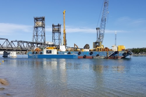
The current equipment on the three huge barges in the Bay at the moment is more than sufficient to drive four piles into the river bed and attach the floating pontoons.  No water or electricity is required.  So that has sorted the engineering problems.

So what is standing in the way of the Minister for Transport for NSW picking up the phone on Monday and just saying “do-it”.  Well for one it would be the Batemans Marine Park Authority giving approval to sink the piles into the river bed – not dissimilar to the two lone piles on the southern bank to secure the small barge.  It would also require Crown Lands to approve, even on a temporary basis, the construction of this piece of infrastructure.  Then there is the inevitable Director of Infrastructure Services at the Council who has on many occasion refused any discussion on placing pontoons at this location in Lions Park.  Does he have the veto?

OK, Minister, use your very persuasive powers and position to get this done and use the same authority that was used to close the bridge to build this temporary piece of infrastructure before the busy holiday period starts and social media lights up with abuse, vitriol and misinformation.

Monday, 25 November 2019

Eurobodalla Shire Council Banned water use at Boat Ramps

The Shire has moved from level 1 to level 3 water restrictions which comes into effect this Monday – December 2.

What that means is that there will be:

  • No boat motor flushing at any of the Shires boat ramps
  • No rinsing of your fish catch and cleaning of the tables at boat ramps.  The taps have been turned off.


The Shire state that if you wish to flush out your motor it has to be done over a grass area.  If you wish to wash the salt off your vessel that has to be done with a bucket but only between 6 and 8 am and 6 and 8 pm.  A final rinse with a trigger nozzel hose.

If you wish to clean the seagull encrusted fish cleaning tables that has to be done with a bucket using sea water.  Do not let it run back into the sea because that would be pollution under the Act.

Now we all want to save water and this is just one step in the right direction. Support this effort and make suggestion on how other measures may be implemented.

Will you be able to take a shower after playing a sport at the venue?

What about taking a shower after a swim at one of the Shire's pools?

What happens in the local marina? Do they again have an exemption?

How can the Shire help the fisho’s?  

Install seawater pumps and connect them to the existing piping so that people you can clean the fish, tables and surrounds with good clean sea water fresh from the sea.

Now that's a good idea and would save the Shire the ongoing maintenance of the boat ramps they so dislike.


Saturday, 23 November 2019

Budget Blow-out at the Batemans Bay Bridge?

The BB Boaters Association Inc represents all forms of recreational and commercial activity on the water of the South Coast of NSW.  Our members enjoy the waters off the town of Batemans Bay as well as travelling the tranquil reaches of the Clyde River to the historic trading port of Nelligen. 

In 1956 a steel vertical lift truss bridge with a maximum height of 34 m was built across the Clyde at Batemans Bay.  The lifting span could be raised on request when both recreational and commercial vessel wished to travel these waterways. 

The Clyde River was first found to be navigable in 1854 and has been a vital link from up-stream to the sea since that time.


In 2015 the Local Member and then treasurer Hon Andrew Constance announced that a new concrete bridge would be built to span the Clyde River at Batemans Bay to replace the current bridge due to “road traffic delays”. 

The height of this new bridge is only 12 metres.  This will deny the continued access by trading and commercial vessels plus most recreational watercraft to Nelligen.  We believe this unilateral decision by the NSW government will breach our rights of free passage under Maritime Law and may contravene a section of the Australian Constitution. 

The final design for the bridge was announced in 2018 and John Holland, a wholly owned Chinese company, won the tender for the construction for the sum of $274 million. 

The Association understands that the current built schedule is at least six months behind planning due in part to a few significant accident which has shut down the Mogo concrete manufacturing facility.  

It is our understanding that the Transport for NSW Departmental flood modeling due diligence report undertaken by GHD has been critically reviewed and brought into question.  The visual evidence of water flowing over the large concrete "boat" structure atop the in-river piles is quite different from the modelling results and that is only at a spring tide and not during a flood. Photo shows average tidal condition.

There appears to be a blow-out in the budget with speculation that it may well be three times the allocated budget. The Association will investigate if the budget for this roads and Infrastructure project has in-fact been adjusted which, if it is the case, will see NSW taxpayers having to fund any shortfalls.

Wednesday, 20 November 2019

The Foreshore Master Plan

The Master Plan and Activation Strategy is a BOLD and BRAVE document put together by the Tasmanian consultants with some great ideas.  Do read the detail and complete the survey.  Their effort and that of the Council hands-on Council project manager should be congratulated for all the effort this weekend. Well done A.R. 

The process to select participants could have been improved and the advertising much wider and longer plus a schedule of pop-up events would have helped.
The consultants listened and explained their views.  Some good others ..very poor like closing the south side boat ramp is not accepted but many other ideas are good.
The choice between a "Youth Central" and an existing boat ramp is not an either or choice as per the survey form - so dont be fooled. Object.
The boat ramp is not a decision made by Council.  It is Dept of Lands paid for in the most part by boat licence fees. So dont any Council employee think that it will be closed down without either a big fight or some negotiation of an off-set for alternative facilities.
Like what?  More floating pontoons at say the oyster farms jetty west of Lions Park.  Not a new idea.


So what next?
Will these ideas be negotiated away by the power that be? Will there be no money to go forward? Or will all the ideas be collated, dissected, reviewed and consolidated to pop out the answers that the powers that be and vested interests want?
Well take a bold step into the sunlight, be transparent, get moving and just do something NOW to show that the Council is serious about activating the foreshore and improving the water land interface.